Rivercast - River Levels App 2.07
Free Version
Publisher Description
Rivercast - River Levels App - Storm headed your way? Get the latest River Levels and Forecasts for the USA!
Are you concerned about flooding? Or just want to go find the best time to go fishing or boating? Get river levels & forecasts with Rivercast™ when you need them!
Rivercast™ puts the river level data you need at your fingertips with its intuitive and interactive maps and graphs!
Rivercast™ Features Include:
• Official Flood Warnings & other alerts from the National Weather Service
• River stage height in Feet
• River flow rate in CFS (when available)
• Indications that a river is at or approaching flood stage
• User-defined Push Notification Alerts for when river reaches levels of concern to you
• Current observations and recent history
• NOAA river forecasts (when available)
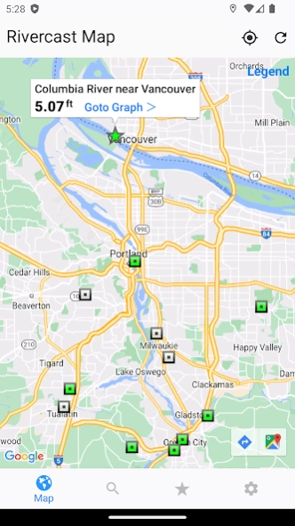
• Map interface that shows where river gauges are located geographically.
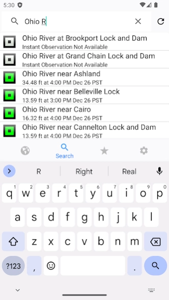
• Search interface to find river gauges by waterway name, state, or NOAA 5 digit station ID.
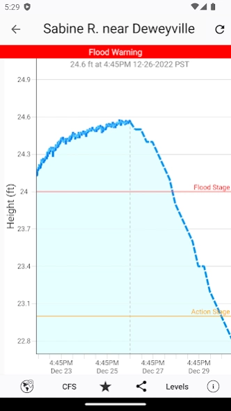
• Interactive graphs that you can zoom in, zoom out, or pan.
• Customize your graphs by adding river levels that are relevant to you.
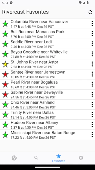
• Favorites list for locations you care about the most.
• Share your graphs via Text, Email, Facebook, Twitter, etc.
• Home Screen Widget to monitor your favorite locations at any time.
Rivercast's map not only shows you where the stations are, but color codes them when it can to give you an indication whether the location is at normal levels, approaching flood levels, or above flood stage.
You can get the latest observations from the map, search, or favorites. With an additional tap of your finger you can get a detailed interactive hydrograph. You can zoom in, zoom out, or pan with your fingers to find the exact information you need.
To customize your graphs for what's important to you, you can add your own level lines to mark sandbars, rocks, bridges, safe conditions, etc. for whatever you would like.
And you can add the streams or rivers that you would like to regularly monitor to your Favorites list for easy "at a glance" viewing.
Rivercast™ uses the latest observation and forecast data available, and requires an Internet connection for use.
Data is viewable in feet or cfs (when available).
All observation and forecast data is in your local time (per your device) for your convenience.
A handy tool for boaters, fishermen, property owners, paddlers, scientists, and the curious.
River gauges reported are USA only.
* * * * * * * * * * * * *
Some Frequent Asked Questions:
Where does Rivercast™ get its data?
• This app uses NOAA and AHPS (Advanced Hydrologic Prediction Service) for its raw data for our custom graphing and mapping solutions. There are a few locations that are available via other government agencies (including USGS) that are not available via this app.
Why does Rivercast™ sometimes show slightly different flow data (CFS) than USGS?
• CFS is a calculated estimate derived from stage height. NOAA and USGS estimates may sometimes slightly vary due to using different data models. Variances are usually within a few percent, but can sometimes be larger. Stage height should always be identical between USGS and NOAA. Designated flood stages are based on stage height in feet in the USA.
Why does Rivercast™ show only observations, but not forecasts, for my river?
• NOAA issues forecasts for many, but not all, rivers it monitors. Sometimes forecasts are only issued seasonally, or during times of flooding or high water.
Can you add location xyz to your app?
• We wish we could! If NOAA is not reporting it, we unfortunately are not able to add it. We include all stations that NOAA provides for public use.
Notice: Raw data used in this app is sourced from www.noaa.gov.
Disclaimer: Rivercast is not affiliated with nor represents NOAA, USGS, or any other government entity.
About Rivercast - River Levels App
Rivercast - River Levels App is a free app for Android published in the Astronomy list of apps, part of Home & Hobby.
The company that develops Rivercast - River Levels App is Juggernaut Technology, Inc.. The latest version released by its developer is 2.07.
To install Rivercast - River Levels App on your Android device, just click the green Continue To App button above to start the installation process. The app is listed on our website since 2024-04-16 and was downloaded 2 times. We have already checked if the download link is safe, however for your own protection we recommend that you scan the downloaded app with your antivirus. Your antivirus may detect the Rivercast - River Levels App as malware as malware if the download link to com.juggernaut_tech.rivercast is broken.
How to install Rivercast - River Levels App on your Android device:
- Click on the Continue To App button on our website. This will redirect you to Google Play.
- Once the Rivercast - River Levels App is shown in the Google Play listing of your Android device, you can start its download and installation. Tap on the Install button located below the search bar and to the right of the app icon.
- A pop-up window with the permissions required by Rivercast - River Levels App will be shown. Click on Accept to continue the process.
- Rivercast - River Levels App will be downloaded onto your device, displaying a progress. Once the download completes, the installation will start and you'll get a notification after the installation is finished.
